
Lot n° 27
Estimation :
1500 - 2000
EUR
Résultats sans frais
Résultat
: 1 500EUR
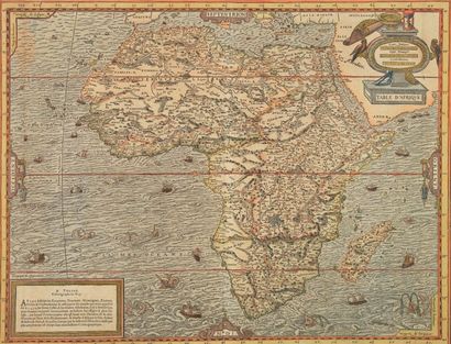
THEVET, A.
Table d'Afrique. Paris, 1575. Col. d'époque. Gravure sur bois en coloris d'époque, coupée en haut à l'ext. du filet d'encadrement, en bas, à l'int. - Wood-cut map in attractive original colours. Upper part cut on the neat line, lower part cut into the neat line. Paper slightly age-toned as usual. Generally in good condition. 345 x 450 mm. (R) Carte publiée dans la "Cosmographie Universelle" d'A.Thevet. C'est la première carte in-folio à s'inspirer largement du modèle de Mercator et pas seulement de celui de Gastaldi-Ortelius. A. Thevet était le cosmographe d'Henri III. - Uncommon wood-cut map. It is the first folio map to show Africa largely based on the Mercator model and not solely that of Gastaldi-Ortelius model. Following Mercator, a major lake is shown to the southwest of the traditional twin Ptolemaic Nile source lakes. The surrounding sea is cut in very great detail. The seas are teeming with numerous small sailing vessels of different shapes and sizes together with a number of kinds of sea monsters. André Thevet was a Franciscan monk who travelled extensively in Europe and made a reputed short journey to South America. - Tooley, The printed maps of the continent of Africa, 98 ; Norwich, 12 ; Betz, The Mapping of Africa, 17.
Mes ordres d'achat
Informations sur la vente
Conditions de vente
Retourner au catalogue